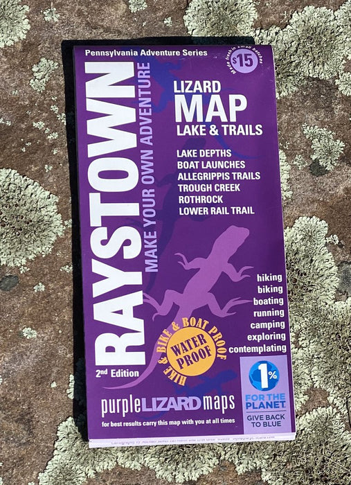
Purple Lizard Map - Raystown 3rd Edition
The Raystown Lizard Map will help you plan all your adventures on and around Raystown Lake. In addition to boasting one of the most action packed recreational lakes in the region, Raystown has one of the best mountain bike trail systems in North America.
A beautifully designed, easy to read topographic map featuring contour lines, elevation data, shaded relief, lake depths, lake navigation markers, and all the key details you need to plan your adventures: backroads and trails, trail use designations, road surfaces (paved/gravel/4wd), parking access, campsites, public lands, historic sites and more.
I love my map! Quality is much higher than could ever be conveyed in words. Keep it up! - Matthew in Pennsylvania
Lizard Maps are durable, waterproof, and give you the big picture – the map opens to 24” x 36” and folds easily to 4” x 8” to fit in your back pocket. The Raystown Lizard Map covers all of Raystown Lake on one side, the scale is 1:45,135 (1 inch = 0.7 mile). A detailed map of the Allegrippis Trail System and Trough Creek State Park is on the other side, the scale is 1:22,588 (1 inch = 0.4 mile). Includes both lat./lon. and UTM coordinate systems.
Public lands: include the entire 30-mile length of Raystown Lake from Huntingdon to Saxton, PA, which is owned and managed by the U.S. Army Corps of Engineers, and a section of Rothrock State Forest and Trough Creek State Park on the eastern side of Raystown Lake, Warriors Path and canoe Creek State Parks and parts of State Game Lands 67, 73, 99, 118, 322.
Destinations: include multiple access areas on Raystown Lake and the Seven Points Recreation Area, the Raystown Lake Visitors Center, several scenic vistas and the Allegrippis Mountain Bike Trails.
Roads: all Lizard Maps show which roads are paved, dirt/gravel or 4wd roads as well as which are gated. Perfect for bicyclists, dual sport riders and overlanders looking to put together a remote backcountry route across public lands.
Major hiking trails: include a section of the 323-mile Mid State Trail (MST) shown from the Lower Rail Trail just south of Water Street, PA, to Williamsburg, PA, and continues south on the ridgeline of Tussey Mountain on the western side of Raystown Lake. The map ends just after the MST crosses PA Route 165. On the eastern side of Raystown Lake, the Terrace Mountain Trail follows the entire lake and has one shelter located north of Trough Creek SP.
Major biking trails: are all about the Allegrippis Mountain Bike Trail System; a favorite destination for cyclists around the country. Dirt Rag magazine holds its annual Dirt Fest event here every spring. This 33-mile network of specially built mountain bike flow trails is considered one of the best riding experiences in the country. A mountain bike skills park is located by the Visitor Center and offers beginner through expert riding opportunities.
Even more trails: Lizard Maps highlight and designate public trails and paths including hiking, biking and rail trails managed by federal, state and local authorities. Juniata College in Huntingdon has a network of walking paths and hiking trails around an environmental art installation by Maya Lin. In Rothrock SF, the trails of Trough Creek State Park are spectacular.
Points of interest: campgrounds, picnic areas, climbing areas, reservable car camping sites, scenic overlooks and lizard spots.
Special Designated Areas: Seven Points Recreation Area offers multiple camping areas, a marina, rental boats, swimming beach, walking paths and picnic areas. Ridenour and Hawn’s Overlooks are easy to access and offer fantastic views of the lake. Trough Creek State Park features a historic balanced rock and ice mine.
Towns: of Alexandria, Broad Top City, Huntingdon, Saxton, Saltillo and Williamsburg, PA.
Lizards: The little purple Lizards you’ll find scattered on the map signify an interesting spot to check out. The Legend says “ This Could Mean Anything: cool place, sweet view, local legend”.